THE Vaal Dam was constructed in 1938 and lies 77km south of the O R Tambo International Airport.
The lake behind the dam wall has a surface area of about 320km² and is 47m deep. The Vaal Dam lies on the Vaal River, which is one of South Africa’s strongest-flowing rivers. It has over 800km of shoreline and is South Africa’s second biggest dam by area and the third largest by volume.
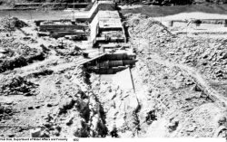
The construction of Vaal Dam started during the Depression of the early 1930s and the dam was completed in 1938 with a wall height of 54.2m and a full supply capacity of 994,000,000m³. The dam is a concrete gravity structure with an earthfill section on the right flank. The dam was subsequently raised in the early 1950s to a height of 60.3m. A second raising took place in 1985 when the wall was raised again.
The flood attenuation properties of the dam were severely tested in February 1996, when the area experienced the largest ever flood recorded at the Vaal Dam site. The Lesotho Highlands Water Project pumps water into the system in order to supply water to the people and industrial complex of Gauteng.
This water is piped from Lesotho into the Liebenbergsvlei and Wilge rivers. The Sterkfontein Dam forms part of the Tugela-Vaal water transfer scheme for the interbasin transfer of water from the Thukela River in KwaZulu-Natal to boost the levels in the Vaal River system. Water from the Sterkfontein Dam is released once the Vaal Dam drops to below 16%.
The dam has its own island some 5km long. The island was used as a secret meeting place by the apartheid government but now hosts the annual Round the Island Yacht race, which is a Guinness Book of World Records title of the largest inland yacht race.